The Latest
-
Fieldwork-why we do what we do!
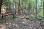
Humidity, spider webs, bear scat: all can be found in eastern Kentucky deep into summer. And despite these things, the sentiments expressed around fieldwork for geographic research include: “Fieldwork is why…
-
Campus Tree Tour
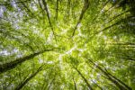
The University of Louisville Center for GIS teamed up years ago with the sustainability efforts on campus to create a walking tour of 31 trees of interest on U of L’s Belknap Campus. Check out the latest refresh of our story map detailing the significance of our essential urban canopy!
-
Remembering the Greatest: Muhammad Ali Storymap Collaboration

Working as part of the multidisciplinary team, the Center for GIS designed a rich interactive experience featuring art around Louisville dedicated to The Greatest, Muhammed Ali.
-
Kentucky Gubernatorial Politics and “…The Great Urban-Rural Divide”

University of Louisville Center for GIS Director DJ Biddle created poignant election result visualizations after the Kentucky Governor’s Race in November 2019. Publishing Louisville’s arts and entertainment news, community, and…
-
GIS Reveals History: Using modern technology to map a lost landscape
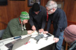
Members from the Departments of History and Geographic and Environmental Sciences went to Perryville, Kentucky to fly drones equipped with cameras.